
Treasure region: South of the River
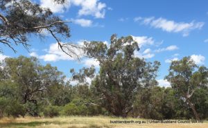
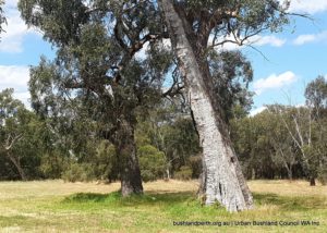
The walk indicated on the first image in the gallery below takes visitors through an outstanding stand of old growth Flooded Gum riverine woodland alongside the lower Helena River and adjacent river flats.
Flooded Gum (Eucalyptus rudis) grows to to 20 metres in height with rough, box-type bark on lower, large branches and smooth grey bark higher in the canopy. White flowers occur from July – September and the foliage has a grey-green to bluish colour.
Old growth trees can have a diameter of up to two metres and there are a number of such specimens in this Reserve.
Included on the route is a short loop encompassing an ephemeral pool. This pool can hold good numbers of waterfowl in season.
The Reserve is also habitat for numerous bushbirds which can be heard calling throughout. See here for a list of birds recorded at this site.
History
Guildford was established in 1829 at the confluence of the Helena River and Swan River, being sited near a permanent fresh water supply.
During Captain Stirling’s exploration for a suitable site to establish a colony on the western side of the Australian continent in the late 1820s, the exploration party of boats found a fresh water stream across the river from the site of Guildford which they called Success Hill.
Guildford was originally the centre of the Swan River Colony before Perth succeeded in being the dominant location of the Swan Coastal Plain.
A Guildford Town Trust was established in 1838, but ceased to function within a couple of years. It was reconstituted in 1863, and became the Municipality of Guildford in 1871.
Guildford was originally the political centre of what is now the City of Swan. The original council chambers have been converted to a library. Alongside the library stands the town hall; behind this is the stables built for the councilors while attending meetings and as a depot for council equipment.
These stables have been converted and are now the home of the Garrick Theatre, which is the oldest operating theatre group in Western Australia. The original structure is still visible. The roof still has its original shingles in place, though from the outside they have been covered by corrugated galvanised iron.
Features that make Guildford special are:
- being bounded by the Helena and Swan Rivers with their wide floodplains
- the original town plan is still visible in the way the town is laid out today
- its town plan was based on a C19 British settlement model used in America with:
- a grid street layout relating to compass points
- a central Church Square
- provision for school, market place, commonages and government lands.
- surviving properties along the floodplains create a rare urban pattern, unique for a town of first settlement in Australia
- a mix of buildings survive in good condition from earliest settlement and each of the major architectural periods since
- significant streetscapes with plantings and buildings from the 19th and early 20th century
Plantings around Guildford survive from early settlement in private gardens, parks and floodplains.
(Source; pers comm, Philip Bianchi. OAM)
Access
There are a number of entry points from the surrounding streets but access is possibly easiest from the children’s playground on River Bend Road opposite Janeville Place. This will locate you at the eastern end of the walk.
Alternatively, there is also street parking at the western end at Bridge St, off Great Eastern Highway, adjacent to a sloping short unformed path onto the walk track.
This trail is located in the Murdoch University Banksia Woodland Reserve, opposite the entrance to the Kennedy Baptist College on Farm Road, Murdoch. It can be reached via Farrington Road, or Discovery Drive. Limited parking is available on the verge, opposite the entrance to the Reserve.
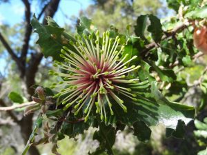
This small reserve has well-made earth paths and some interpretive signage. In Spring it has a glorious display of wildflowers.
Bring your own water supply as there are no facilities in the reserve. To avoid spreading dieback disease, you should stay on the path and make sure you brush your shoes at the cleaning stations at the start and end of the trail.
Length: 1 kilometre
Walk Time: 30 minutes
Class: 2 (level bush track)
Start: Farm Road, Murdoch University, opposite the entrance to Kennedy Baptist College
End: loop trail, ends 100metres south of start.
Facilities: interpretive signage
The Trail:
- Start your walk at the northern gate of the reserve. Brush your shoes before you start.
- Follow the trail eastwards through a heavily wooded area dominated by jarrah and balga, plus occasional remnant pine trees from the previous pine plantation which bordered the reserve on the northern side.
- Along this section of the Poolgarla Trail you should see abundant displays of wildflowers in the Spring, including cowslips, native wisteria and prickly bitter pea. See the List of Species in Flower for more details about what is flowering at various times of the year.
- After walking 400 metres you will reach the end of the reserve and the trail swings to the right to commence the return journey.
- As you continue the trail swing right again and heads west, back to Farm Road. Along this section of the trail you will see revegetation efforts underway to control weed invasion from the neighbouring animal paddocks. There is a good display of red and green kangaroo paws (Anigozanthus manglesii) that have been planted in this section.
- Continuing westwards you will soon reach a biologically diverse area will abundant wildflowers in the Spring. They include greenhood, donkey and cowslip orchids, buttercups, native wisteria, hovea, milkmaids, purple tassels and scarlet runner. See the List of species in flower for more details.
- This reserve has abundant animal life including honeyeaters, black cockatoos, rainbow lorikeets and quendas.
- As you reach the end if your walk you will see a spectacular display of orchids and hovea near the exit gate in Spring. Don’t forget to wipe your shoes as you leave, to avoid spreading dieback disease.