Koondoola Regional Bushland

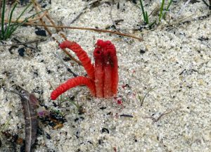
Red Fingers Colus pusillus.

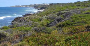
Koondoola Regional Bushland is a near pristine remnant of the Swan Coastal Plain.  It has stunning scenery and is an extremely precious site.

It is 137 hectares in size and 15 km from the Perth CBD.  It is a regionally significant area of remnant bushland.  It is located in Koondoola between Alexander Drive, Marangaroo Drive, Koondoola Avenue and Waddington Crescent.

Koondoola Regional Bushland is a Bush Forever  site as well as being a bushland linkage (as part of Greenways 12 & 13).

Its extensive reptile population includes the Significant listed reptile Gould’s Goanna (Varanus gouldii).

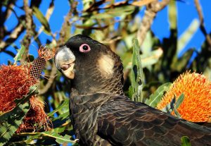
Its significant bird species include Carnaby’s Cockatoo, Western Thornbill and Splendid Fairy Wren.

Its Significant listed flora include Waldjumi (Jacksonia sericea), Drummond’s Featherflower (Verticordia drummondii) and Morrison (Verticordia nitens).

Landforms and Soils
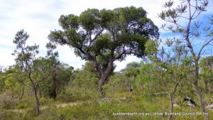
Jarrah.

Koondoola Regional Bushland is located on the Spearwood Dune System with the southeast part of the bushland being a transition zone to the Bassendean Dune system and delineated by a line of swamps and lakes.

The Spearwood Dunes are relatively young, of aeolian origin with a degraded surface as a result of leaching, and with complex patterns of erosion and superdeposition. The dunes have relatively high hills and a variable topography.

The soils in the Spearwood Dune system are Karrakatta Soils consisting of deep, leached yellow and brown sands overlying limestone at depth.

In the Bassendean Dune System, the soils are Bassendean Soils; grey, with some yellow quartz sands

Vegetation and Flora
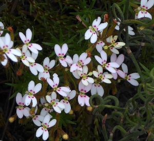
Stylidium adpressum.

Koondoola Regional Bushland is located within the Karrakatta – Central and South Vegetation Complex and is typically dominated by Jarrah ( Eucalyptus marginata) and banksia species and with a diverse understorey.

At the boundary of the Karrakatta and Bassendean Complexes, the dominant vegetation types are Jarrah (E. marginata), Sheoak (Allocasuarina fraseriana) and banksia species transitioning to woodlands of melaleuca species and Flooded Gum (E. rudis) and sedgelands on moister sites.

274 plant species have been recorded in these two key vegetation communities.

Landscape Quality

The two seasonal wetlands in the Southern portion of the Bushland, and the dunal formation in the Northern area have high scenic value.  There is a distinct contrast with the sumplands in the low dunes and depressions of the Bassendean Dune System.  This contrast is striking!

Access

The Bushland contains approximately 8.6 km of limestone paths and a further 9.2 km of sand tracks with a number of pedestrian entrances. See site access map:  Download.

Resources

Bush Forever Site Map   Download.     Bush Forever Description   Download.        Bush Forever Species List  Download.

Source of Information

Sourced (with kind permission) from City of Wanneroo – Koondoola Regional Bushland Management Plan.

Please note that permissions are required from the City for further usage.

Kings Park

Kings Park and Botanic Garden is is located adjacent to the Swan River, just 1.5 km from the Central Business District of Perth, with a total area of 400 hectares.  It is visited by over 6 million people each year.
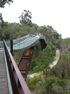
Within the Kings Park bushland, three major plant communities are supported – limestone heathland; Banksia woodland with B. attenuata (Slender Banksia), B. grandis (Bull Banksia), B. menziesii (Firewood Banksia) and B. prionotes (Acorn Banksia); and low moist areas with Banksia ilicifolia (Holly-leaved Banksia).


324 species of local native plants – or 15% of the native flora of the Perth region – are found in Kings Park.

Kings Park is a Bush Forever site. Download the Bush Forever listing here.

Walking in Kings Park

A number of ‘formal’ walks are described on the Kings Park website; two are featured here.

Bushland Nature Trail

Bush in the Heart of the City: Start this 25 minute walk at the Botanic Garden car park on Forrest Drive. This walk offers an encounter with Western Australia’s famous wildflowers, trees and birdlife living in the wild as they have done for millions of years. If you are lucky you might see a bobtail lizard or some of the other bushland fauna.

An open mia-mia structure marks the entry to this walk.  It draws upon the key architectural elements of the temporary shelters built by Nyoongar people and provides an opportunity to express this aspect of Aboriginal culture in a unique and interesting way.

Law Walk

Law Walk is Kings Park’s premier urban bushland trail. It is a 2.5 km loop walk in limestone heathland that takes approximately 45 minutes to complete. The terrain is a bit ‘up and down’, and requires reasonable fitness. The main path is hardened and is suitable for wheelchairs and prams.

Named after Robert Oswald Law, Law Walk begins at the War Memorial and continues along the ridge of the limestone escarpment to Dryandra Lookout, where a loop walk returns visitors via the Lotterywest Federation Walkway. Law Walk offers spactacular views and takes you through an excellent tract of local flora.


Informal walking trails

Kings Park is ‘crisscrossed’ by an extensive network of walk trails. These range in condition from sandy to varying degrees, to paved paths, and are supported by some internal signage.  They provide visitors with outstanding ‘near city’ bush appreciation opportunities – The Kings Park Bush Forever listing notes the Park bushland as being 15% in excellent condition, with the remaining 85% as being in ‘very good to good’ condition. A map of the pathways, including information regarding path surfaces is available here.

Source of Information

The material presented on the page is sourced from the Western Australian Botanic Gardens and Parks Authority.

Inglewood Triangle

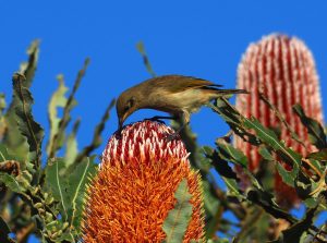
Brown Honeyeater

Inglewood Triangle is a small 1.7 hectare ‘postage stamp’ of natural bushland, also known as Walter Hamer Eighth Reserve, and is located 5 km north east of the Perth GPO, bounded by Walter Road, Hamer Parade and Eigth Avenue in Inglewood. It is an A class reserve managed by the City of Stirling‘s Parks and Reserve Department with on-ground assistance by the Friends of Inglewood Triangle supported by the City of Stirling.

UBC has not been able to discover records indicating exactly how Inglewood Triangle escaped the bulldozer. This serendipity must have occurred in the 60s subsequent to the construction of Walter Road to intersect Hamer Parade and Eighth Avenue.

The Triangle was part of Perth Location Ab and never sold (see Gallery – last image).

It is in a low lying area, a lot of which was swampy, which may partly explain why it was left undeveloped from the 1930’s, unlike surrounding lands. The area was unfenced. It was probably grazed by cows from the nearby Quinn’s Dairy (258 Eighth Ave) which operated from 1916 to about 1945. Its shape and size did not lend to any particular purpose so it was just left. (Source: Mount Lawley Society).

Nevertheless,  This bushland could have been long cleared for other purposes had it not been listed for conservation in 1992, in City of Stirling Green Plan 1 (A Strategy for the Conservation of Urban Bushland)  by a far-sighted City employee. 
Green Plan 1 was developed after it was realised that small bushland pockets in parkland reserves were being systematically cleared for turf establishment. The central thrust of the Plan was that preservation and management of small bushland remnants was equally as important as preserving large bushland blocks for ecological linking and sustainability of local environments. 

The Bushland

Woodland

The Triangle is a near City example of a Banksia Woodland community and is situated on the Bassendean Sands landform. It provides a window into the past showing the natural bushland that once covered the area to the immediate north of Perth.

The nine tree species present in the Triangle are common to the Perth region thus providing a wonderful outdoor classroom for students of all ages. Along with the Banksias there are Balgas (grass trees), orchids, an extensive ground cover of rushes and sedges, hosting reptiles and birds.

The Triangle, while very small in extent, and while its vegetation and structure is perhaps better represented in much larger banksia dominated reserves such as Koondoola Bushland, is selected as a Treasure because, apart from Kings Park, it is one of the two closest substantially intact bush remnants to the Perth CBD. (See also Kensington Bushland).

It may well be ‘postage stamp’ sized, but it is packed with bushland diversity – as such it is a special gem! To date, an impressive 89 native plants have been identified in the Triangle. 


Carnaby

Inglewood Triangle bushland is in particularly good condition considering it is located within an established urban area. It forms part of an ecological corridor with Mount Lawley Golf Course, Macauley Park, Hamer Park and Yokine Reserve.

Nevertheless, there is a range of impacts threatening the biodiversity of the Triangle including weeds, unleashed dogs, cats, foxes, bushfires, dieback, feral bees, litter from passing motorists, herbicide spraying over many years, declining ground water and climate change. The Friends work actively to manage these and are very welcoming of new volunteers.

Access

Access is easiest at the Reserve gate on Eighth Avenue. Please remember when visiting Inglewood Triangle: Dogs on leashes only, and, please clean your footwear at the dieback stations located at the entrances to the Triangle.

Resources

Field Guide to the Plants of Inglewood Triangle.

Field Guide to the Birds of Inglewood Triangle.

Fungi and Slime Moulds of Inglewood Triangle.

Also, see Friends of Inglewood Triangle page.

Iluka Foreshore Reserve

Iluka Foreshore Reserve is a narrow strip of coastal bushland located south of Burns Beach to the Ocean Reef marina, 25 km northwest of Perth.

The scenery is spectacular with rugged limestone cliffs, consolidated limestone dunes and high quality coastal vegetation. Looking out to sea is the Marmion Marine Park, an area with very high conservation value. The Reserve is a Bush Forever site.

Start your visit to the Iluka Foreshore Reserve at either the car park at the end of Burns Beach Road or at Iluka Foreshore Park as per the Google map, this page.  The Reserve has a very easy walkway over its entire length which is suitable for wheelchairs.

Landform and Vegetation

The Joondalup coast consists of dune limestone, in patches overlain by low sand dune ridges known as the Quindalup dune system. The plants in this area are usually found in a sequence, from beach foredune landward.

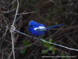
The vegetation provides a wonderful habitat for fairywrens with three species (White-winged Fairy Wren, Splendid Fairy Wren and Purple-backed Fairy Wren) regularly seen.

WWFW.

Near the beach, at the back of the beach face, are the salt-tolerant grasses such as Spinifex.  On the dunes further back from the beach are the ground cover plants, other grasses and low shrubs such as Olearia and Scaevola.

Further inland are Spyridium, and on the limestone at Ocean Reef and Iluka are three species of Melaleuca: Melaleuca systena, Melaleuca cardiophylla, and Melaleuca huegelii.  Still further back, in the more moist swales and depressions are found small trees; predominently banksias and eucalypts.


Spring is the main flowering time with the white splashes of Chenile Honeymyrtle the most prolific.

Bush Forever Site Map. Download.   Bush Forever Description. Download.   Bush Forever Species List.  Download.

Source of Information.

The Joondalup Community Coast Care Forum has a range of information on its website.


Herdsman Lake Regional Park

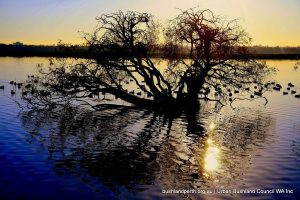
Herdsman Silhouette.

Herdsman Lake Regional Park, 7 km northwest of the CBD, is Perth’s largest inner metropolitan wetland and consists of permanent water bodies, seasonally dry wetlands and open parklands.  It is part of a narrow chain of wetlands that extends parallel to the coast from Yanchep in the north to Mandurah in the south in the Spearwood Dune System.

It is an extremely important wetland on the Swan Coastal Plain as it supports a wide diversity of wildlife species; serves as an important bird breeding ground and is a summer refuge for transequatorial migratory birds. Herdsman Lake is a Bush Forever site.  Download Listing.

Herdsman Lake contains an inner wetland (approximately 160 hectares in area) which is dominated by Bulrush (Typha orientalis) and a dredged outer moat consisting of four deep permanent water bodies (Floreat Waters, Popeye Lake, Powis Lake and Floreat Lakes joined by small channels restricting access to the central conservation area.

Start your visit to Herdsman Lake at the Herdsman Lake Wildlife Centre at the southern end on the corner of Selby & Flynn St, Wembley or at the northern car park near Selby Street North and Jon Sanders Drive, Herdsman. Scenic views over the wetland can be enjoyed from the Wildlife Centre, while observation of wildlife on the open water can be made from two bird hides and most sections of the Lake’s edge.

Park Vegetation

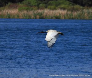
Australian White Ibis.

The vegetation types in the Park are primarily wetland communities that are either sedgelands dominated by Typha orientalis or woodlands with an overstorey of either Melaleuca rhaphiophylla, Eucalyptus rudis, or Eucalyptus camaldulensis.   (Note that Eucalyptus camaldulensis is not a naturally occurring species at this location).

The wetland communities in the Park are influenced by, and are dependent on, the hydrological zones within the lake system. Sedgeland communities dominate the fringing open-water areas; the wet-forest and woodland communities are in the seasonally inundated margins between the open water and the dryer recreation areas.

The native sedgeland communities throughout the Park extend into the understorey of the forest and woodland. By contrast the Typha orientalis communities only occur where there is no shading overstorey.

The vegetation of Herdsman Lake has changed a great deal since European settlement. Reports by early European settlers describe the Lake as an area of open water with fringing rushes and fresh water paperbarks (Melaleuca rhaphiophylla) giving way to swamp banksia (Banksia littoralis) and flooded gum (Eucalyptus rudis) with an understorey of shrubs.

Herdsman Birdlife

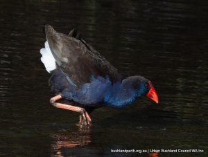
Australasian Swamphen.

Herdsman Lake contains one of the most varied and easily observed waterbird fauna of any Lake in southwestern Australia due primarily to its wide range of habitats including: deep, open water (approx. 1.5 – 2.5 metres); shallow water, seasonally inundated areas (including mud flats and sedge lands); grassy banks of drains and the shoreline; dense stands of rushes; and trees.


It is an important breeding site with at least 20 species, including Black Swan, Australasian Swamphen, Little Grassbird  and Australian Reed-Warbler. Areas in the central wetland in summer provide habitat for bird species such as White-fronted Chat and Australian Pipit, while in winter, these areas are covered by deeper water and are used by ducks and other water birds.

Two species recorded at the Park, Australasian Bittern and Peregrine Falcon, are listed as specially protected under the Wildlife Conservation Act 1950. From a conservation viewpoint, the presence of Buff-banded Rail, Baillon’s Crake, Australian Spotted Crake and Spotless Crake is important (Curry, 1981).

A number of migratory birds listed under the Japan- Australia Migratory Birds Agreement (JAMBA) and the China-Australia Migratory Birds Agreement (CAMBA) have been sighted at the Park.

It is one of the few wetlands in southwestern Australia where Australian Little Bittern breed.  Another three bird species which are rarely found breeding in the southwest, Blue-billed Duck, Hardhead and Australasian Shoveler nest at Herdsman Lake.

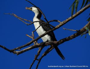
Little Pied Cormorant.

Particularly visible are the three grebe species – the Australasian Grebe, Hoary-headed Grebe and Great Crested Grebe – which construct floating nests on the open water.  Eurasian Coot also breeds in abundance.

Pink-eared Duck, Musk Duck and Dusky Moorhen are also present at the Lake.  Freckled Duck also occasionally occur.

Herdsman Lake is also used regularly by small numbers of freshwater migratory waders such as Sharp-tailed Sandpiper, Common Greenshank, Wood Sandpiper and Long-toed Stint (Curry, 1981). Long-toed stint is uncommon in the area and it’s occurrence at Herdsman Lake is significant.

Several Australian waders also occur in the Park and four of them – Black-fronted Dotterel, Red-kneed Dotterel, Red-capped Plover, and Pied Stilt have been recorded as breeding at the Lake.

A list of birds seen at this location can be found here.

Cultural Heritage

Stone chips and flakes found on the higher ground to the north of Herdsman Lake indicate past Aboriginal use. Aboriginal people call the area Ngurgenboro and used it as a food source.

Further Information

The material presented here is sourced from the Herdsman Lake Regional Park Management Plan 2004 – 2013.

For a more extensive Image Gallery of Perth’s waterbirds visit our Wetland Birds page.

Donations

Donations and support from the wider community help us to protect and campaign for our Urban Bushland.

Make a donation

newsletter Signup

Get the latest news and key events delivered to your inbox.

Become a Member

We are a peak environmental group in WA. One of our key strengths is our amazing group and individual members.

Become member
Location

Urban Bushland Council WA Inc

2 Delhi Street, West Perth, WA, 6005

(08) 9420 7207 (please leave a message)