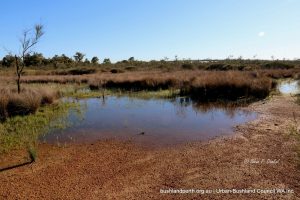
A Botanical Jewel: The Greater Brixton Street Wetlands, Kenwick is the most floristically diverse Bush Forever site on the Swan Coastal Plain and has many more species than Kings Park. It is located on the very flat, waterlogged Pinjarra Plain at the base of the Darling Range in an area that has largely been cleared for agriculture or housing.
The wetlands are less than 20 km south of the Perth CBD, in an area between Roe Highway, Albany Highway and Kenwick Road in Kenwick.
While the wetlands only cover 19 hectares, they contain many different vegetated wetlands with fringing vegetation in or near to the original condition, support an outstanding flora diversity with at least 518 native taxa and comprising a third of the taxa recorded on the Swan Coastal Plain. This includes many plant communities that are rare or endangered and in need of species protection.
The wetlands have been entered into the Interim List of the Register of the National Estate and are subject to protection under Commonwealth legislation.
The Wetlands support over 80 special wildflowers that are either rare and endangered; or have only recently been discovered by botanists; or are uncommon on the Swan Coastal Plain.
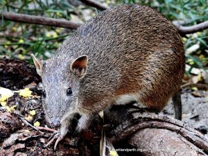
They are also habitat for the Quenda (Southern Brown Bandicoot), waterbirds and many native terrestrial and aquatic animals as well as for endangered Carnaby’s Black Cocktoos.
Access to Brixton Street Wetland
Brixton Street Wetlands are accessed via Brixton Street and Alton Street, with the main entry and site lookout off Alton Street. The Wetlands are always worth a visit, with the best times being early morning in September or October when many species of plants are flowering and bird life is prolific; especially early in the morning.
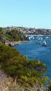
Blackwall Reach Reserve, and Point Walter Bushland both comprise parts of Point Walter Reserve gazetted for recreation. It is approximately 20 hectares in size. The reserve is vested in the City of Melville. Blackwall Reach Reserve is bounded by Honour Avenue along its eastern boundary fairway, and the Swan River along its western boundary. It is a Bush Forever site.
History
To the local Aboriginal people the Blackwall Reach/Point Walter area is known as Jenalup or Dyundalup. The most sacred part of the area is the cliffs along Blackwall Reach. In Aboriginal culture it was traditionally a place for women and children. Before white settlement the Beeliar family group (clan) occupied the area. The Beeliar clan is part of the Whadjuk, being one of the 14 language groups, which occupy the Nyungar region in the South-West of WA.
One of the many dreaming trails which run along the Swan River passed through the area now known as Point Walter and Blackwall Reach. The Swan River is highly significant to the Nyungar people, as, in the dreaming, the river was made by the Waugal rainbow serpent. The dreaming trail on the southern side of the river is the Yorga (women’s) trail and the men’s trail is found on the northern side. The sand bar, which stretches out from the point, is the connection between these two trails.
Blackwall Reach Reserve has been Crown land since the late 1800’s. Commander L. S. Dawson R. N. Admiralty Surveyor named the area Blackwall Reach in 1896 – probably after Blackwall Reach on theThames River near Greenwich. In the early 1900’s, the Melville Road Board (now Melville City Council) received complaints regarding the “neglected and unimproved state” of Point Walter. From 1907 to 1912, negotiations ensued with the Minister for Lands for the Melville Road Board to take control of the reserve.
The Melville Road Board soon decided that land communication with Point Walter was essential since river steamers did not provide an adequate service and the road to Point Walter was “little better than a bush track”. In 1915 a tram service was established to Point Walter. It was not a successful operation. The service rarely showed a profit except in the summer months. The tram service did bring Point Walter to life, however. It became a popular picnic spot and restaurants and a dance floor were established.
Physical Environment
Blackwall Reach Reserve is situated on the western edge of the Spearwood Dune System. The Swan Coastal Plain consists of a series of coastal dunes, running roughly parallel to the coastline. The Spearwood Dune System is bound to the east by the Bassendean Dune System and to the west by the Quindalup Dune System. Each system has a distinctive geology, vegetation, topography, drainage pattern and soil characteristics.
In the Spearwood Dune System, leaching has occurred causing the carbonate to precipitate below to form hard compact limestone. At Blackwall Reach this limestone is exposed at the surface.
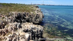
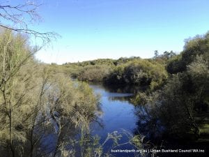
One of the most prominent features of the Blackwall Reach Reserve is the limestone cliffs that rise eight metres out of the Swan River. The cliffs have been formed by the eroding processes of the river, which flows from the wide expanse of Mosman Bay into the narrow gap of Blackwall Reach.
Rainfall has caused the limestone to be deeply attacked physically and chemically producing frequently sharp points and ledges. The soil in the reserve is predominantly brown sand. There is deep yellow sand in the vicinity of the adjacent practice fairway.
Vegetation
River Foreshore.
The river foreshore contains sedges and rushes such as Juncus maritimus and Lepidosperma gladiatum (coastal sword sedge). On the banks are tall specimens of Casuarina obesa (swamp sheoak), Agonis flexuosa (peppermint trees), and Hardenbergia comptoniana (native wisteria) and Acacia cyclops (red-eyed wattle).
Limestone Cliffs.
Scattered throughout and along the eight metre high cliffs is a variety of vegetation adapted to living on limestone and with salt spray. These include Olearia axillaris (coast daisy bush), Rhagodia baccata (berry salt bush), Alyxia buxiflora and Clematis microphylla (old man’s beard).
Limestone Heath.
The limestone heath vegetation grows on a mixture of limestone outcrops and shallow soil. The heath vegetation includes the richest and most diverse of the vegetation zone in the reserve. The upperstorey vegetation consists mainly of Acacia cyclops (red-eyed wattle), Dryandra sessilis (parrotbush) and Agonis flexuosa. The understorey consists of such species as Scaevola holosericea, Hakea prostrata (harsh hakea), Grevillia thelemanniana, Hibbertia racemosa, Melaleuca systena (formerly M.acerosa) and Templetonia retusa (cockies tongue).
Shrubland.
In areas dominated by shrubs, the shrub layer is occupied by Dryandra sessilis (parrot bush) and Agonis flexuosa (peppermint tree) with occasional Eucalyptus gomphocephala (tuart), Banksia attenuata (slender banksia), Banksia menziesii (firewood banksia) and Banksia grandis (bull banksia). The understorey consists chiefly of Xanthorrhoea preissii (blackboy), Macrozamia riedlei (zamia), Ptilotus polystachyus (mulla mulla), Jacksonia sternbergiana (stinkwood), J. furcellata and Hakea prostrata (harsh hakea).
Woodland.
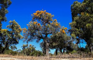
The woodland areas vary across the reserve in dominant tree species present and condition. There are generally two main areas of dominance, consisting of tuart (Eucalyptus gomphocephala), jarrah (Eucalyptus marginata) and marri trees (Corymbia calophylla).
The tuart woodlands occur in a variety of locations throughout the reserve. The main areas of tuart are at the southern and northern ends of the reserve. The species is also found around the cliffs and some limestone outcrops, together with peppermint trees. There are some magnificent old tuarts in the reserve. The other woodland areas in the reserve are mainly dominated by jarrah and marri with occasional tuart.
Recreational Opportunities
Recreational opportunities abound at Blackwall Reach. Choose from: easy walking in a bush environment, family picnicing, cycling along the dual use path, pumping the legs in a truly scenic setting, nature observation, Point Walter Spit and adjacent amenities…it’s all there.
Resources
City of Melville – Blackwall Reach and Point Walter Bushland Management Plan.
Beeliar Regional Park contains a large range of coastal wetlands in the south western corridor in the cities of Melville, Cockburn and Kwinana. It provides a wonderland of nature appreciation options.
The Beeliar Wetlands are internationally significant. The entire Park has been placed on the Interim List of the Register of the National Estate, while Booragoon Lake, Thomsons Lake and The Spectacles have been listed on the Directory of Important Wetlands in Australia (Environment Australia 2001).
Thomsons Lake (in conjunction with Forrestdale Lake) has been listed as a wetland of international importance under the Ramsar Convention. Many wetland areas in the Park have also been identified as locations for JAMBA / CAMBA/ROKAMBA migratory bird species.
Beeliar Regional Park provides significant landscape and amenity value to the region. Many landscapes contribute to the overall high visual quality of the Park. These include vegetated uplands consisting of mature woodland and forest areas, vegetated wetland areas, extensive areas of open water and areas of well maintained grassed parkland. The coastal environments of the Henderson foreshore area, which comprises limestone cliff formations and coastal vegetation, also add another positive dimension to the Park’s landscape amenity.
The vegetation communities found within Beeliar Regional Park are significant as they represent communities which were once widespread on the Swan Coastal Plain but are now heavily cleared. The vegetation within the Park comprises both structural and floral diversity expressed as a diverse series of landscapes. A number of Park areas contain priority flora species, as well as a large number and wide range of plant communities some of which are in very good condition.
The diversity of habitat is important to wildlife utilising the Park. The wetlands and surrounding areas provide important nesting and feeding habitats and because of their high biological productivity, they directly or indirectly support most of the wildlife of the region. Additionally, some wetlands in the Park act as summer refuges for a diverse bird population, many of which are transequatorial migratory waders.
Cultural Values
Beeliar Regional Park has cultural significance to both Aboriginal and non-Aboriginal people. There are numerous Aboriginal sites within, or immediately adjacent to the Park which have been registered with the Department of Indigenous Affairs.
The wetlands of Beeliar Regional Park holds significance for the local Aboriginal people (Whadjuk Nyungars) as they were important camping, ceremonial areas and sources of food.
The eastern chain of wetlands was a part of a major trade route between Aboriginal people in the Swan and Murray River areas. North Lake and Bibra Lake in particular are areas of spirituality for the Whadjuk Nyungar people.
Non-Aboriginal people also have historical connections to the area. Thomas Peel first occupied the area in 1830 and established the Clarence settlement near Mt Brown. However, it was not until the late nineteenth century that intensive agriculture commenced in the area, coinciding with the gold rush in the 1890s.
Landscape Values
Beeliar Regional Park provides significant landscape and amenity value to the region. Many landscapes contribute to the overall high visual quality of the Park. These include vegetated uplands consisting of mature woodland and forest areas, vegetated wetland areas, extensive areas of open water and areas of well maintained grassed parkland.
The coastal environments of the Henderson foreshore area, which comprises limestone cliff formations and coastal vegetation, also add a dimension to the Park’s landscape amenity.
Bushland Appreciation
In particular, Thomsons Lake, Bibra Lake, Piney Lake, Manning Lake, the Henderson Foreshore, Mount Brown, and The Spectacles provide excellent, relatively easy, walk trails encompassing a variety of habitats. Appendix B (pp 66-67) of themanagement planoutlines the trails and access points to the network.
Park Components
Beeliar Regional Park comprises numerous separately designated areas which can be identified at page 10 of the management plan. Areas within the Park have been the subject of numerous studies, and a wide range of literature exists that covers the biological, cultural and recreational aspects of the Park. Detailed information on specific locations is mostly available via a Google Map search.
Components having published information include: Blue Gum Lake, Booragoon Lake, Piney Lakes, North Lake, Bibra Lake, Little Rush Lake, Yangebup Lake, Thomsons Lake Nature Reserve, Lake Coogee, Market Garden Swamps, Henderson Region (Mount Brown and Brownman Swamps).
Bibra Lake
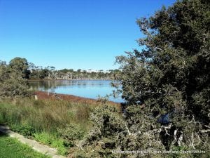
Bibra Lake is the recreational hub of the Beeliar Regional Park. It has a variety of attractions, including a regional children’s playground, extensive picnic areas, Adventureworld, the Cockburn Ice Arena, Native ARC and the Wetlands Centre. There is a 6.2 km concrete path around the lake, with two hides and two jetties, from which visitors can obtain excellent views of the birdlife. The path is also suitable for wheelchairs and bicycles. As well, the Woodland to Wetland walktrail is very rewarding. Download further information here.
Manning Lake
Situated in Hamilton Hill, Manning Lake is a popular recreational area in the western chain of the Beeliar wetlands. It has the Azelia Ley historical museum, plus an orchestral shell and amphitheatre, extensive grassed picnic areas and a children’s playground. There is a short circuit trail around the lake (1,5 km) with three vantage points for bird watching. There is also a popular bush walk called the Davilak Heritage Trail (2.5 km) which starts at the Azelia Ley homestead and climbs to the top of the limestone ridge. There are three lookouts on the ridge, and these provide spectacular views over the Lake and Owen Anchorage.
Piney Lake
Piney Lake in Winthrop is the site of the City of Melville’s Environmental Education Centre. The reserve includes a seasonal wetland, with a boardwalk and a 1 km circuit trail. This trail also has some interesting environmental sculptures and interpretive signage. The remainder of the reserve includes a grassed picnic area, a children’s sensory playground and an ornamental pond, which often attracts waterbirds. It is a popular spot for picnics and bushwalks.
Thomsons Lake Nature Reserve
Thomsons Lake is encircled by a main walking track, accessible from gates on on Russell Road and Branch Circus. There is a delightful walk of about two hours duration (8km) but care needs to be taken to watch for snakes which are occasionally seen on the path.
The circuit may also be overlapped at the northern end and on the eastern side by rising Lake waters in wetter months. A detailed management plan is available for this Reserve. Thomsons Lake is a Bush Forever site. Download the Thomsons Lake Bush Forever listing here.
The Spectacles
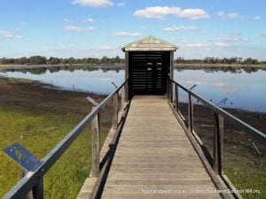
The Spectacles, like Thomsons Lake is circled by a main walk track accessible from a gate on McLaughlan Road. This is also a delightful walk of about two hours (7km) duration but again, care needs to be taken to watch for snakes which are occasionally seen on the path. There is also (signed) a short option for a walk through the Banksia woodland. A lovely feature of the loop walk is a boardwalk to the centre of the paperbark forest from which the birdlife can be observed. The Spectacles is a Bush Forever site. The Spectacles Bush Forever listing is here.
Henderson Cliffs, Mount Brown, Brownman Swamp.
The Henderson Region of the Park offers a variety of landscapes including the Henderson Cliffs overlooking Cockburn Sound (viewing platform). A walk up Mount Brown is a must, resulting in great views all round. Henderson/Mount Brown is a Bush Forever site.
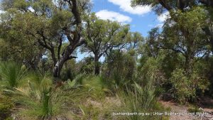
A Botanical Jewel: The Anstey-Keane Dampland is the second most floristically diverse Bush Forever site on the Swan Coastal Plain and has more plant species than Kings Park. More importantly, its vegetation is in excellent condition. It is an area of high biological importance.
This small patch of bush is home to a remarkable diversity of plant species amid an ever-encroaching urban environment. It is located about 30 km south of the Perth CBD in the heart of semirural and semi-urban Forrestdale between Nicholson Road and Tonkin Highway and north of Armadale Road. Anstey – Keane Dampland forms an important part of the Jandakot Regional Park.
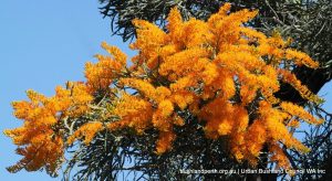
The bush here harbours 381 plant species including the swamp fox banksia (Banksia telmatiaea), one-sided bottlebrush (Calothamnus hirsutus), swamp cypress (Actinostrobus pyramidalis), sand bottlebrush (Beaufortia squarrosa), and Regelia ciliata. They provide important habitat for the southern-brown bandicoot, or quenda (Isoodon obesulus).
Access to Anstey-Keane Dampland
Access Anstey-Keane Dampland by using the stile at the corner of Anstey and Keane Roads as indicated by the placemark on the map below. Sandy tracks fan out from here north and west. The best time to visit is early in the morning in September or October when many plants are flowering and when bird life is prolific.
Threats
Anstey-Keane Dampland was under threat from a City of Armadale development application. The good news – Environment Minister Jacobs ruled, 14 Nov 2014, against the application!
The bad news; the Water Corporation is now proposing an equally unacceptable easement for a wastewater pipeline through the Reserve.
Read all about Anstey Keane as published in Kwongan Matters.
The material presented here is partly sourced from DPaW’s Landscope Winter Edition 2009. Detailed information on adjacent Forrestdale Lake is available from the Forrestdale Lake Management Plan. The Jandakot Regional Park Management Plan provides further context.

 To the local Aboriginal people the Blackwall Reach/Point Walter area is known as Jenalup or Dyundalup. The most sacred part of the area is the cliffs along Blackwall Reach. In Aboriginal culture it was traditionally a place for women and children. Before white settlement the Beeliar family group (clan) occupied the area. The Beeliar clan is part of the Whadjuk, being one of the 14 language groups, which occupy the Nyungar region in the South-West of WA.
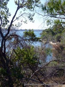 Blackwall Reach Reserve is situated on the western edge of the Spearwood Dune System. The Swan Coastal Plain consists of a series of coastal dunes, running roughly parallel to the coastline. The Spearwood Dune System is bound to the east by the Bassendean Dune System and to the west by the Quindalup Dune System. Each system has a distinctive geology, vegetation, topography, drainage pattern and soil characteristics.
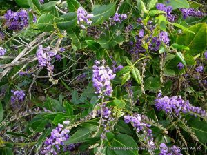 River Foreshore.
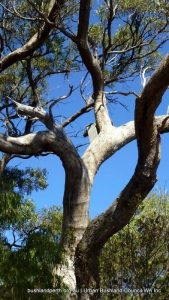 The woodland areas vary across the reserve in dominant tree species present and condition. There are generally two main areas of dominance, consisting of tuart (Eucalyptus gomphocephala), jarrah (Eucalyptus marginata) and marri trees (Corymbia calophylla).
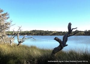
 Bibra Lake is the recreational hub of the Beeliar Regional Park. It has a variety of attractions, including a regional children’s playground, extensive picnic areas, Adventureworld, the Cockburn Ice Arena, Native ARC and the Wetlands Centre. There is a 6.2 km concrete path around the lake, with two hides and two jetties, from which visitors can obtain excellent views of the
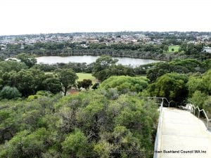
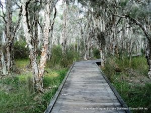 Piney Lake in Winthrop is the site of the City of Melville’s Environmental Education Centre. The reserve includes a seasonal wetland, with a boardwalk and a 1 km circuit trail. This trail also has some interesting environmental sculptures and interpretive signage. The remainder of the reserve includes a grassed picnic area, a children’s sensory playground and an ornamental pond, which often attracts waterbirds. It is a popular spot for picnics and bushwalks.
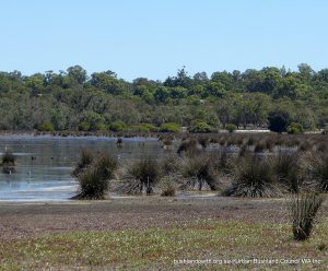
 The Spectacles, like Thomsons Lake is circled by a main walk track accessible from a gate on McLaughlan Road. This is also a delightful walk of about two hours (7km) duration but again, care needs to be taken to watch for snakes which are occasionally seen on the path. There is also (signed) a short option for a walk through the Banksia woodland. A lovely feature of the loop walk is a boardwalk to the centre of the paperbark forest from which the